• expired

GME MT610G GPS Personal Locator Beacon $299 Delivered @ ARB Tamworth

590

Not sure why it's on sale, but it's nearly a historical low. These don't go on sale often, so it seems like a decent deal. And if it saves your life then even better ¯_(ツ)_/¯

Can be had at:

-

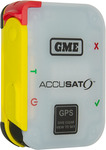
The MT610G is a super-compact, lightweight PLB, offering an impressive 7-year battery life and a 6-year warranty. Featuring a ‘Non-Hazmat’ battery pack for ease of transport, the MT610G ensures you remain safe and connected, wherever life takes you.

Featuring an integrated 72 channel GPS receiver, zero warm-up time, high-intensity LEDs, IP68 Ingress Protection, and an inherently buoyant design, the compact size of the MT610G has not compromised the safety features included.

The MT610G is designed to meet and exceed the latest international standards and is Cospas-Sarsat Class 2 certified.

GME is the only Australian manufacturer of emergency beacons and has been designing, engineering, and manufacturing EPIRBs and PLBs for over 30 years. In that time our beacons have been used to save hundreds of lives around the world.

The MT610G offers enhanced peace of mind for bushwalkers, 4WDers, remote workers, and aviators alike.

Related Stores

ABR Tamworth
ABR Tamworth

closed Comments

        • +4

          Calling 000 without an address and nearest cross street is going to get you help more slowly than a beacon / AMSA coordination centre.

          Very true, which is a good reason for everyone to have the Emergency Plus app installed on their phone. It's an official app developed by the government that will display your coordinates and what3words for you to relay to emergency services.

        • Not true in many states, your phone will self report its lcostion to 000

    • Not if it's a life threatening situation, and doing that in the outback absolutely can be.

  • +4

    If you're not needing one right away, supercheap often has 25% off storewide and the Rescue Me PLB drops to $299.

    https://www.supercheapauto.com.au/p/ocean-signal-ocean-signa…

  • Does this work outside of Australia?

    • +1

      Yes they do work worldwide. The international SARS centre communicates with the centre of the country that the beacon is registered to and then they co-ordinate with the local authorities of the country it was triggered in.

    • Yes, but subject to the emergency services that country provides.
      Plenty will just go "meh", hopefully they call your contact who can unlock action with promises of $$$$$.

  • great for next Cast Away moment

  • +6

    Going to get one for my wife for when she is shopping at Chadstone.

  • Right across the New England, you're listening to FM100.3

  • +4

    Really would suggest anyone looking to buy on of these call the store and ask for the date of manufacture, as lifespan is from this point not date of purchase.
    The batteries have a set lifespan before replacement which is often the cost of a new unit.

  • Cheers. Bought one. If i get stuck in the toilet one day the Westpac helicopter can winch me out.

    • +1

      Fat elvis has entered the chat.

  • can this be used to track a bentley if stolen?

    • only if the Bentley can push the button to track it else you are better off with an AirTag hidden inside the Bentley

      • thanks, but don't airtags alerts other iphone users occasionally?

  • I am taking this the next time I fly Malaysia Airline……..

    (By the way someone knows something about MH370)

  • Good deal, though I'd say the EPIRBs are about to disappear in a year or 2

    https://www.androidauthority.com/motorola-defy-satellite-lin…

    Called Motorola Defy Satellite Link, this $99 gadget connects via Bluetooth to any Android or iOS device and allows it to connect to a network of geostationary satellites. It allows sending and receiving short text messages, location sharing, and accessing emergency services. A clear view of the sky is just about the only requirement.

    • +6

      That'll never make PLB's or EPIRB's obsolete as it won't meet the required standards set for emergency beacons.

      It'll be a good alternative for messaging etc. and could be good to carry in addition to your locator beacon, but because it doesn't have 6-7 year battery life, and requires the user to pay a subscription fee it's a totally different use case.

    • +3

      Consumer-level satellite messaging and phone calls have been available worldwide for decades via the Iridium satellite constellation. That didn't make EPIRBs obsolete, so I don't see how this newer system will either.

      Iridium was also designed by Motorola.

      • -3

        It won't make them totally obsolete. But I for one won't be replacing my Epirb when the battery is due to be replaced, I have one for safety not because it is a legal requirement for me. This technology is coming to phones so won't even need to buy this device. Satellite phones and subscriptions are very expensive where a this is not and subscriptions for basic messaging is quite cheap. Free for emergency texts for the first 12 months and the paid plans are cheap if you only subscribe when you are going anywhere you would want a PLB.

        • Satellite phones and subscriptions are very expensive

          It is expensive in Australia, but is cheaper elsewhere in the world. For example, the Thuraya satellite phone, using a geosynchronous satellite above the Indian Ocean, is US$29/month, plus $1/minute for calls:

          https://www.satphonestore.com/airtime/thuraya-airtime.html

          Unfortunately Australia isn't in the "footprint" for that satellite, so we can't use it. Thursday have other satellites, one of which covers Australia, but I don't think it's the same price.

          • +4

            @Russ: I would still call $29 a month expensive. And a quick search of the phone shows it is about $1000. Compare that to an Epirb/ PLB I would go the Epirb. But if included in my phone at no extra cost with zero or minimal subscription cost bye bye Epirb. That is for me, others may still want an Epirb/PLB but i am guessing a lot won't see the point.

            • @ikey2: Agreed, it's not for everyone. But it has its uses for people who work remote and offshore. Particularly if you want to let your work and family know "the job is taking longer than expected, it will take three days longer than planned, I'll be home on the 7th".

          • @Russ:

            For example, the Thuraya satellite phone, using a geosynchronous satellite above the Indian Ocean, is US$29/month, plus $1/minute for calls:
            Unfortunately Australia isn't in the "footprint" for that satellite, so we can't use it.

            Thuraya definitely works here, even down to Tassie. When I go out of mobile coverage I would reactivate either my Thuraya or Iridium SIM depending on where I'm going. Thuraya plans start at AUD$16.50 a month and you can start/stop it on a monthly basis with Pivotel. It used to be $15/month but they raised it this year.

            You get a standard 04xx Australian mobile number so you can receive calls anywhere within Australia for free. People calling you will pay regular mobile rates. So technically you could just give your contact a missed call and they can call you back for free.

            If you have a standard Telstra SIM you can activate international roaming and use that in an Iridium phone. Just be prepared for eye-watering calling costs. It's fine for emergencies though, where you'll be happy to pay $4/min.

            • @eug: Thanks for the pricing info, I couldn't find Australian pricing with a quick internet search. Thuraya is much more reasonable than I expected!

              Iridium seems to be getting a little cheaper, I last used it about a dozen years ago, and I vaguely recall the calls were $8/minute. Not that you could call for long, dropouts were common.

              With Thuraya being a geosync satellite, is the delay a problem when making calls via the satellite?

              • +1

                @Russ:

                Iridium seems to be getting a little cheaper, I last used it about a dozen years ago, and I vaguely recall the calls were $8/minute. Not that you could call for long, dropouts were common.

                Haha, $8/min is shocking! They now start at "just" $1.98/min on the cheapest $65/month plan and down to $1.20/min for higher plans, which all come with a bit of included call value. You also get free incoming calls though, which makes it more palatable.

                With Thuraya being a geosync satellite, is the delay a problem when making calls via the satellite?

                It's definitely there, but nothing too bothersome, especially if you're used to two-way radios. You won't get dropouts like Iridium though, as long as you have a clear view northwest. The satellite on our side is roughly above Singapore.

                BTW calls to 000 are free on Iridium and Thuraya even without a SIM in the phone. So if the only reason is for emergencies, you don't even need a monthly plan.

        • +2

          But I for one won't be replacing my Epirb when the battery is due to be replaced, I have one for safety not because it is a legal requirement for me. This technology is coming to phones so won't even need to buy this device.

          EPIRB/PLB's are a hell of a lot more reliable and foolproof than anything else, at $300 per 7 years why wouldn't you carry one if you're spending time in remote areas, that's significantly cheaper than a 1-year subscription on any other service, and cheaper than a tank of fuel in the areas you're likely to make use of one, lol ….

          The phone/sat-phone options will never be as good as a dedicated emergency beacon operating through the dedicated SAR satellites…

          • @FLICKIT: Free for SOS functions is cheaper and also includes two way messaging. A lot of people go to remote areas now without an Epirb or PLB. So their standard phones with Satellite emergency features is a big step up and will suit many people.

            • @ikey2: So "standard phones" can now communicate with the Cospas-Sarsat satellites ? or are you just talking about the fairly unreliable sat phone networks?

              • @FLICKIT: I am talking about the phones that are starting to come out with the required hardware. Some Iphones already have the feature. Qualcomm has announced it for this year and Samsung is adding it to their Exynos processors. I am not totally sure what satellite systems they can each use.

            • +1

              @ikey2: Hmmmm. "Emergency SOS via satellite is available in the U.S., Canada, France, Germany, Ireland, and the U.K"…

              Good luck with your $1200+ iphone, I think I'll stick with my $300 dedicated PLB to save my life…

              I assume you're someone that never steps outside suburbia and has never seriously considered dealing with life and death out in a real world remote area?

        • This is dangerous misinfornation, and you do not understand the differences between the devices.

          We are not in "primary" coverage zone for spot, we're in a data only zone and its degraded performance for a reason.

          The same as iridium, there are times where the gap between satellites means one satellite is well north of aus while the next is well south. That means your line of site angle to either is relatively low on the sky, so best hope your emergency is occuring somewhere with a convenient sightline.

          Epirb can be picked up by a geostationary satellites always hovering above, and globally orbiting lower ones.

          Then when Services are on the way, spots etc do not broadcast a local radio homing signal like epirbs / plbs do, that can help land or aerial teams find you.

          Phones also do not have any if these epirb features, and do not get picked up by the epirb satellites. 9r broadcast a local beacon. And are incredibly low powered without extendable antennas. They are last resort, fragile, go flat. and should not be part of planned risk mitigation at all.

          Again. They are not equivalent. Not even close.

          Please do not give advice regarding life and death emergency safety equipment when you have the barest understanding of it, and can't be bothered researching answers when asked. You're not an expert of this topic. Stop trying to pass as one. You might just get someone killed.

    • +2

      That has nothing to do with a PLB. Might replace traditional satellite phones, that's about it. But even that's a while away.

    • connects via Bluetooth to any Android or iOS device

      so, your emergency needs are linked to the battery status of your Android/iOS device

      • There is an SOS button on the device itself.

  • can this be used to track my girlfriend?

    • Not where she goes.

    • Airtags is what you need.

      • -1

        is there anything better than airtags? they pop up with a message in the phone

        • You could use a Samsung SmartTag. It seems to work better than an AirTag anyway.

          I'm assuming you aren't actually trying to track a person…

          • @eug:

            I'm assuming you aren't actually trying to track a person…

            I believe they wanted too.

            can this be used to track my girlfriend?

            • +1

              @xoom:

              I believe they wanted too.

              I thought he was joking. :/

  • Featuring an integrated 72 channel GPS receiver,

    That's some A-grade marketing BS in the specifications.

    Each channel can receive the tracking signal of one GPS satellite.

    Problem is, there aren't 72 GPS satellites and never have been. There are currently a total of 31 GPS satellites, which includes spare satellites. 24 form a "full constellation", and less than half of these can be received at any time, as most of them are "below the horizon", i.e. on the other side of the Earth. This is why 12-channel GPS receivers are so common.

    However having up to 31 channels makes it slightly faster to achieve a position fix, as the receiver doesn't have to work out which satellites are receivable, and then "tune" each channel to those satellites. (It's not actually tuning, but it's a suitable analogy).

    But the advantage of more channels goes down pretty quickly. With a 12-channel receiver, a "cold" position fix takes up to four minutes. A 31-channel receiver might shave 30 seconds off that.

    72 channels is either a lie, or ridiculously over-engineered for negligible benefit.

    Here's the complete list of GPS satellites ever launched:
    https://en.m.wikipedia.org/wiki/List_of_GPS_satellites

    • +1

      I don't know much about satellites and their locations but OziExplorer regularly reports to me that I'm connected to 20+ satellites. Ozi is a well regarded, no BS bit of software.

      Edit. I'm sitting at the local soccer grounds waiting for my son's game to start and Ozi says it's connected to 35 satellites…

      • See my answer below.

        • So you've gone from saying 34 satellites total to 100 being visible?

          As I said, I'm no expert, but I don't believe that OziExplorer is lying to me, and I'm not confident in relying on Wikipedia links.

          • @wombat81: Actually I said less than 100 visible, of which many are unusable.

            I'm not confident in relying on Wikipedia links.

            Then confirm it however you like, Wikipedia has references from the websites of those networks. GPS only needs 24 satellites for worldwide coverage, and there are four networks claiming to have global coverage, each saying they need about the same number of satellites (plus a few spare and performing other functions). The maths says about 120 satellites, less than half of which are above the horizon, and not all are usable.

            For the GPS network, I've seen previous technical docs. Only ten satellites of the 31 in use are visible in the best locations.

            • +1

              @Russ: So OziExplorer is just making up numbers? Sorry, I don't believe it.

    • +1

      GPS is just one constellation of navigation satellites. Once you add in Japan's, Europe's, China's and Russia's GNSS satellites there are plenty of useable satellites.

      GME is just sharing the specs of the GNSS receiver chip that's installed in the unit, and those specs state that it has 72 channels.

      See the ublox NEO-M8P series as an example. https://content.u-blox.com/sites/default/files/NEO-M8P_Produ…

      • -1

        there are plenty of useable satellites.

        Except there aren't. None of the other satellite constellations have worldwide coverage, and only over the countries that created them are there sufficient satellites to use them. They still orbit over the rest of the world, so you can see them, but you usually can't see enough of them to get a position fix. And you can't use a mixture of satellites from different systems to get a fix - at least not in real-time, in consumer-level equipment.

        Also note that some of the satellites your nav system shows are SBAS satellites, which are useless to you. They give extra information to achieve centimetre-level precision, if you have a position fix from other satellites. You can't use SBAS satellites to obtain a position.

        • +1

          I'd better hand back my spatial science degree, because if everything you say is true I've been hoodwinked for the last couple of decades. The GNSS receiver in my ute has a 864 channel chip that uses QSZZ, GPS, GLONASS and BeiDou satellites and a combination of all satellites have been used for PPK calculations. Seeing 30+ satellites at once is normal.

          99.9% of currently produced consumer grade GNSS devices will use a combination of GPS and GLONASS together to compute a position.

          • @frugalferret:

            The GNSS receiver in my ute has a 864 channel chip

            Have a look here: https://en.m.wikipedia.org/wiki/Satellite_navigation

            Under "comparison of systems", it lists how many satellites are actually operational in each network, and the total of all networks doesn't reach 200. Of which less than 100 are above the horizon on average.

            So an 864-channel receiver is either ridiculously overbuilt, or more likely it's a lie put out by the manufacturer, knowing they're unlikely to be caught out.

            Receiving positions from multiple satellite constellations isn't going to be useful for EPIRBs or PLBs, they only need one constellation, and GPS works everywhere in the world.

            I had a teensy-tiny part in building Australia's first GPS receiver, at Auspace in 1991.

            Also, I was wrong above, some of the other networks DO have global coverage. But whenever I use my GPS app, although it shows the other satellites, it always gets position first from the GPS network, and then continues to use GPS sats.

            • +1

              @Russ: Rather than relying on Wikipedia for your knowledge a look here - https://globalgpssystems.com/gnss/understanding-satellite-fr…

              Each constellation has about 5 separate frequencies, so that's why my work GNSS receiver has so many channels, because it's recording 30+ satellites and many frequencies at any one time. To future proof hardware they are constructed so that they can handle extra satellites and frequencies in the future.

              Yes, most consumer GNSS equipment is single frequency, so only needs one channel per satellite, and that's perfectly fine for a emergency locator beacon, but some phones are now using dual frequency receivers, so with to RTK corrections can increase accuracy from 5m down to 10cm.

              You said initially that the 72 channel claim is either a downright lie, or over engineered. It's neither.

              • @frugalferret:

                Each constellation has about 5 separate frequencies

                In the GPS system, only the L1 frequency is for consumer use, the rest are military and encrypted. Unless you work for the military, regularly receive the encryption keys, and have a military-grade GPS receiver, you won't be able to use the other frequencies.

                • +1

                  @Russ: I think your source of information is about 20 years out of date.

                  Selective availability was turned off in 2000. That increased consumer grade GNSS accuracy from 100m to 10m, and all frequencies are now utilised by many different industries.

                  https://www.septentrio.com/en/learn-more/about-GNSS/why-mult…

                  • @frugalferret:

                    I think your source of information is about 20 years out of date.

                    I also suspect this is the case.

                  • @frugalferret: Was nice reading the thread. Even through most of it is above my head, I do feel I learnt a thing or two.

                  • @frugalferret:

                    Selective availability was turned off in 2000

                    Selective availability has nothing to do with the different GPS frequencies. Selective availability was the ability of the GPS satellites to deliberately give a wrong position on the civilian L1 frequency, as the military don't want it to be used for targeting missiles and drones.

                    To counter this, other superpowers launched their own positioning satellite networks, which made selective availability useless, and in fact it hindered the US military in the 1991 gulf war when they couldn't get enough military GPS receivers for their own troops, and had to use cilvilian-grade GPS receivers which gave less-accurate positions due to selective availability.

                    But as I said above, selective availability has nothing to do with the other GPS frequencies.

                    • @Russ: Me, im just tickled that gps has to account for the theory of relativity, as some satellites clocks are ticking slower than we perceive time due to their incredible speed.

                      A positioning system that has to factor in kinetic and gravity field caused time dilation. I use it to order burgers.

                      Amazing.

  • would you know if this actually activated a rescue, example if you're in a jungle and the way it works seems to indicate you need to be at a clearing etc? How would you know if this actually triggered a rescue and also can you move around to a source of water/safety/shelter after activating or are you supposed to stay put?

    • +2

      These are quite powerful, the signal will generally get through the forest canopy.. If they cant get a GPS fix they still send out an emergency signal which gets triangulated to calculate your rough location from the satellites… They also send out a secondary VHF radio signal which they can use to pinpoint your location with a radio direction finder…

      If you can move to a clearing it's not a bad idea, if you need to move to water to survive you do what you have to do.. In an idea world you stay with your vehicle and such… These will transmit continuously for 24+ hours, once it dies it's probably wise to stay put and not move…

      • +1

        They also send out a secondary VHF radio signal

        That signal is at 121.5MHz, which is within the radio band that aircraft use to communicate with airports. So all commercial aircraft should be able to receive it using one of their standard radios, no special equipment required.

        Commercial aircraft are sometime redirected to fly over an area where someone has gone missing, to see if they can pick up a signal and give a rough location. But that was used more with the previous generation of EPIRBs/PLBs that didn't transmit their location.

        • Commercial aircraft dont have range or bearing detecting radios on board capable of being of used for detecting that signal and giving any real idea of its location.

          Commercial aircraft diverting to chase a half watt warbly noise isnt really a thing, particularly since 406 entered the scene.

          • @[Deactivated]: They don't need to. Say you have a boat missing off the northern WA coast. There are tens of international jets flying over every day, on multiple flight paths. Diverting a few planes slightly can "fill in" the gaps between the standard flight paths, and each aircraft notes where the signal rose above the noise floor, and where it disappeared.

            When plotted on a map, the location where signal is present can narrow a search from tens of thousands of square kilometres to hundreds of square kilometres, and spotter aircraft take over from there.

            The commercial aircraft narrow down the search area dramatically, without causing any significant difficulty to the aircraft, and they can do this in the middle of the night when visual searching is not possible.

            Remember, at cruising altitude of 35000 feet, the horizon is only about 370km away. You won't receive a signal from a sea-level EPIRB that is over the horizon. So you get a circle about 700km diameter, with the EPIRB near the middle.

            isnt really a thing, particularly since 406 entered the scene

            Which I already mentioned:

            But that was used more with the previous generation of EPIRBs/PLBs that didn't transmit their location.

            • @Russ:

              spotter aircraft take over from there.

              Spotter aircraft are sent immediately to the vicinity because they have the homing gear on board. Spotter aircraft are one of several challenger jets with 5,500km range, Or ADF Poseidon's, if they feel like going out to play, which are based on the 737 airframe. Nnot some barnyard hick sent up in a biplane. There is zero need for commercial airliners to "be diverted" to pick up a signal. It's not a thing.

              Modern beacons can send their GPS co-ordinate out to the satellite so you've got a pretty precise "rough area" to start with. Factor in an hour or two of ocean currents pushing you in "x" direction,….no, none of this is required. Sure, maybe in 1970. Not for a long, long time.

              they can do this in the middle of the night when visual searching is not possible

              But boats/people stand out like dogs balls on infra red at night, which ever SAR craft has.

              Remember, at cruising altitude of 35000 feet, the horizon is only about 370km away.

              Remember, you've read a few things but don't actually know how it works.

              • @[Deactivated]: I suggest you re-read what I said, you seem to think I said a heap of things I didn't say.

                But boats/people stand out like dogs balls on infra red at night

                Debris on the ocean from a broken-up boat, and dead bodies, don't show up at all on IR.

                • @Russ: Luckily the mission isn't to find dead people. That's a secondary goal.

    • No you won't know. You should seek shelter etc if your life's in imminent danger but be aware that the signal generates a GPS location accurate to within 100-200m so you last location will likely be where searchers will be focusing initially. EPIRBS keep signalling for about 48 hours, PLBs at least 24 hours. Signals can get through trees but it depends on the density obviously. Best to find a spot open to the sky as you say. This may be out of date info so always check official sites. AMSA will answer questions fairly quickly ime.

  • +1

    Don't forget to register your device with AMSA. When you activate it AMSA will look up your details and attempt to call your nominated contact numbers. This will usually be a partner or friend who can confirm that the registered owner is bushwalking in the Blue Mountains, has a heart condition, wearing a red hat, etc. AMSA will then call the rescue helicopter with those details, as well as the GPS co-ordinates as sent by the PLB. The helo will head for the given position, and as it gets close will be able to pinpoint a more accurate location by homing in on the VHF signal (121.5 MHz) which is continuously transmitted by the PLB and picked up by a device in the helicopter. There are many, many instances of unnecessary beacon searches carried out due to accidental activation of unregistered and/or discarded devices.

  • Let's say we buy one.

    And go out bush, and get stranded.

    Then activate it, and rescue comes.

    Who's paying for the chopper / rescue service?

    • +2

      In NSW the state rescue helicopters are contracted to NSW Ambulance and carry a doctor and paramedic. I believe you get charged something like the cost of a standard ambulance trip, (which your health fund would pay) but not sure as I've never been on the receiving end.

    • +1

      In Tasmania it is 100% free for everyone, it's paid for by taxpayers, even if you're a dimwitt that sets it off because the walk you're doing is a lot harder than you expected and poor diddums has blisters, lol, I'm not sure about other states..

      (and the Tas Gov pays for all ambulance fees in other states for Tassie citizens so I assume it would be free for "me" everywhere in Aus)

    • +2

      Generally the state pays to arrange rescue services (Police, SES, whatever) to locate you, but you will be charged the bill for the ambulance / air ambulance trip to hospital.

      Some states such as QLD and TAS pay the ambulance bill for their residents regardless of where it happens, for everyone else there is optional ambulance cover.

      I have not read of a case in Australia where someone who needed rescue was presented with the full bill that covered every aspect of the operation. It will probably bankrupt them as the cost to operate a helicopter alone is a few thousand per hour.

      • I have not read of a case in Australia where someone who needed rescue was presented with the full bill

        Foreigners in Australia can apparently be charged full cost. Read about Abby Sunderland, a young round-the-world yacht sailor, who was charged $300,000 for her sea rescue, some 2000 nautical miles off the WA coast:

        https://www.adelaidenow.com.au/news/family-cannot-afford-to-…

    • The hundreds of billions worth of nuclear subs the LNP bought will come to rescue you

      • +1

        No need. Prayer will save you, but you'll have to convert to Pentecostalism first.

  • $315 now

  • can these devices be carried on an airplane? do they need to be checked in?

Login or Join to leave a comment