• expired

Topographic Maps 33% off – Larapinta Trail $32.80, Budawangs $18.06 Delivered @ NSWTOPO

250
SAVE33

For the bushwalkers and cartography buffs out there. I'm offering a 33% discount on the two topographic maps that I've designed and published. These are high-quality topographic maps printed on waterproof synthetic paper. I have two publications available:

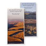
  • West MacDonnell Ranges and the Larapinta Trail: a map set covering the awesome Larapinta Trail, a 230km long-distance walking trail in the West MacDonnell Ranges west of Alice Springs. The set comprise two map sheets, each double-sided (four maps in total) at 1:40000 scale. It includes all facilities and access points along the trail. Having walked it myself, I can recommend it to any bushwalker as a real bucket-list trip, with scenery which is just stunning. These maps would also be good as a gift to inspire a bushwalking friend or family member.

  • The Budawangs: A Bushwalker’s Guide: a double-sided, 1:30000-scale map for the Budawangs, an amazing wilderness area in Morton National Park between Sydney and Canberra. This is a new map I've just published this year. The Budawangs has never previously had a dedicated topo map, and this one replaces four or five separate government maps.

I ship these maps by AusPost letter service, so between 2-6 business days for delivery.

Related Stores

NSWTOPO
NSWTOPO

closed Comments

  • do you unfold maps on the hood of your car?

    • +8

      That sounds like more of a Russell Coight thing…

  • Not for me but these look really cool.

    • Thanks, appreciate it! A labour of love.

  • What extent does the Larapinta map series cover to the south? Does it show detail down to Namatjira Dve, or even further such as Finke Gorge etc? Thanks

    • +1

      All of Namatjira Dve is on the map, running along the bottom of the maps, all the way west to the Mount Sonder turnoff. But no, not Finke Gorge. Pretty much all the West MacDonnell Ranges are shown, except for Mt Zeil and Mt Razorback at the far west of the range.

  • Wow, i'm not about to grab those maps (i'm thousands of kms away) … but may check out some of your digital topo ones.
    Had a play around with Avenza last time i was up at Cape Range and it was pretty handy.

    Appreciate the work you've put in here.

  • +2

    I am sure that your maps have plenty of features, remember that:
    The Qld Govt provide free printable topographic maps for the whole of Qld, including N.P. walking trails here: https://qtopo.information.qld.gov.au/
    NSW also available here: https://maps.six.nsw.gov.au/etopo.html
    Tassie here: https://maps.thelist.tas.gov.au/listmap/app/list/map
    Happy trails.

    • +1

      Yes, state governments were slow to provide good digital topographic offerings, but things are a lot better now. Particularly in NSW where the eTopo PDFs are free to download. These PDFs are typically georeferenced so you can import them into an offline GPS app like Avenza. At the same time, the printed government maps in 1:25000 are being phased out, as they are expensive to produce and many are low-volume.

  • Thanks. Look forward to receiving the Budawangs one (just ordered). Many of my friends have well worn government paper ones. Not only are they showing extreme signs of use, needing to have several different ones depending on where you’re going is a pain.

    • Great, thanks! I hope it serves you well.

  • Ordered the Larapinta Trail one. Thank you, OP.
    I am planning to attempt the walk in the coming autumn. A printed map is always a safety essence.

    • Cheers! Good luck, I hope you'll love the walk. If you have warm weather, my tip would be to get going early in the day and be done by the afternoon.

      • +1

        Just realised that the Parks and Wildlife Commission North Territory (PWCNT) also publishes an official information pack, which includes:
        * A poster-sized folded trail map, and
        * 12-section maps with notes on rip-proof, waterproof paper with a plastic pocket.

        Figured it might be a good idea to share this information here.

      • Yes, the government map pack is another good option. The main difference being that those maps are smaller and there are more of them, so you don't get as much context as on a larger map like these ones.

  • +1

    Thanks OP, I just picked mine up from my PO Box this morning and it looks (and feels) really good. I like the attention to detail like some (old?) tracks being labelled “overgrown”, or tracks like Mt Talaterang just west of Gadara Pt labelled “indistinct” (I can vouch for this when we did it a year ago). That’s just from a quick inspection.
    Also having the whole Budawangs on a double sided map is a great idea.
    If anyone has been hesitating, I say just grab it.

Login or Join to leave a comment